
A summerlike airmass is still hanging over New England on Saturday, and we expect storms to roll through.
Vermont has already seen some action, with isolated showers, thunder and even a couple severe thunderstorm warnings throughout the day. An earlier warning for western Massachusetts has since expired.
Stream NBC10 Boston news for free, 24/7, wherever you are.
More energy builds in as the day goes on and as a low pressure system moves closer.
A severe thunderstorm warning was issued through 9:15 p.m. for parts of southern and central New Hampshire due to the threat of 60 mph wind gusts and nickel-sized hail, but that has since expired.
Get updates on what's happening in Boston to your inbox with our News Headlines newsletter.
[Get the latest severe weather alerts here.]
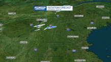
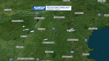
With a “triple point,” some storms are expected to rotate as a warm front and cold front immediately follows through. The area of concern: Vermont, north and central New Hampshire, and western Massachusetts from 2-8 p.m. for rotating storms that MAY produce a spin up tornado, damaging wind, and hail. Stay tuned for any watches or warnings that are issued.
Live radar: Track the storms
Local
In-depth news coverage of the Greater Boston and New England area.


Meanwhile, in southern New England and in Boston our storms are much slower to move in. Much of the day will be free from heavy rain. Maybe a spot shower, but no storms until roughly 6-10 p.m. And those storms are from what ever develops out west. There's an isolated chance for damaging wind, hail, along with heavy rain and lightning as the main threats. Overnight thunder is possible for all too.
Severe storm risk Saturday

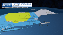
Tornadoes possible in Mass., NH, Vermont
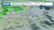
Sunday forecast
Less humid air rolls in behind the cold front to start off Sunday. And some sunshine welcomes us into next week. Temps stay in the 60s to 70s all day long, with increasing clouds thanks to daytime heating.
Also, as a cool pool of air is aloft and the low pressure system is now positioned near Maine and Canada, showers pop up in the afternoon and combine with wrap around moisture. The afternoon wind gusts ramp up a bit too.
Next week this low seems to stall nearby to our northeast, so Monday clouds hang tight as temps drop to the 60s.
Then on Tuesday, highs fall a bit more though we expect some sun.
Wednesday through Friday, a coastal low forms and swings in some wind, clouds, and waves of rain, along with highs in the 40s to 50s. That's not typical for this time of the year at all!
We seem to kick out this storm by Memorial Day weekend as temperatures return to the 60s by Saturday.